 |

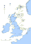
Click here to see full
page map of North Sea oil and gas
fields
|
How
does the search begin?
Rock structures that contain oil or gas are hidden
from view by the sea or non-productive rocks. Drilling in
many locations to see if fuel deposits exist is very
expensive, so other methods are used to try to determine
what might lie below the seabed. Remote sensing surveys
are carried out from ships and these make no direct
contact with the rock structures beneath the sea. The aim
is to discover as much as possible about the nature of
the rocks, by collecting magnetic and gravitational
information.
Identifying
the rocks
There are clear differences between igneous rocks and
sedimentary rocks. Igneous rocks are formed when hot,
molten magma from the Earth's interior cools and
solidifies. Igneous rocks in the North Sea never contain
fossil fuels. Sedimentary rocks have a different origin.
They are formed when small, worn particles of sediment
are compressed together. We know that soft, sedimentary
rocks that may contain oil or gas are less dense than the
heavy igneous rocks that lie below them. Sedimentary
rocks also have much weaker magnetic properties than
igneous rocks which contain a lot of magnetic minerals.
These differences are easily and cheaply detectable using
equipment on board survey ships that follow accurately
plotted courses across the North Sea.
 |
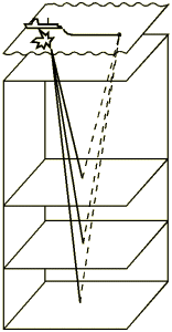
| Seismic survey of
several rock layers |
Seismic
surveys
Once a promising area has been located, a second stage
of exploration is undertaken. This involves a more
expensive seismic survey using a powerful submerged air
gun. It sends out pulses or waves at regular intervals.
The wave signals then bounce back off of the various
layers of rock under the sea and are picked up by a chain
of sensitive listening devices called hydrophones. These
are trailed behind the survey vessel in a long line
containing up to 240 instruments. The enormous quantity
of information received from these surveys is stored and
processed by computer.
Interpreting
the signals
 |
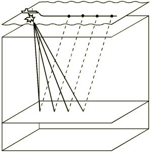
Detailed seismic
survey
of a single
rock layer |
Geologists then record the time taken for the pulse to
leave the air gun, to hit the various rock layers under
the seabed and travel back up to the hydrophores near the
surface. The longer the time taken for the echoes of
sound to come back from the reflecting layers of rock,
the thicker those layers of rock must be. The seismic
signals are plotted on a chart, which enables the
geologists to form a comprehensive picture of the rock
layers under the seabed. Each peak on the chart
represents a boundary between layers. Sometimes the
signals can bounce around inside the layers, which gives
confusing multiple readings. The signals can also split
up into many separate paths if they hit a broken rock
layer, but with care and experience a geologist can
filter out the misleading signals.
Drilling
- the final test
Having found a suitable rock structure that might hold
gas or oil deposits, the only way to confirm a find is to
start drilling. The chances of discovering oil or gas in
economically viable quantities are considerably improved
by using surveying techniques, rather than 'wild cat' (speculative)
drilling. The drilling takes place from a mobile
exploration rig. Exploration drilling rigs are basically
of two types: jack-up rigs used in shallow water less
than 100 metres deep and semi-submersible rigs used in
deeper waters.
Finding
out more
During exploration of the well, various tests are
frequently carried out. The tip of the drill is extremely
hard and triple-headed. This tri-cone bit grinds up rock
into tea-leaf sized cuttings, which are then brought up
to the surface in a slurry of mud and sieved out. They
are examined under ultraviolet light because oil will
fluoresce (glow) when UV light hits it and thus show up
more clearly. Solid cores of rock and any gas given off
can be collected and analysed. A variety of measuring
devices are lowered down the well on a wire line. These
detect differences in porosity (the amount of pores that
occur in the rock) and the electrical resistivity of the
rock (how difficult it is for an electric current to pass
through the rock). This information in turn gives clear
indications of how much oil and/or gas may be present and
how easily oil could flow through the rock.
The
recovery factor
In deciding whether or not to go ahead with full-scale
production at a particular site, developers must consider
the recovery factor - this means the amount of oil and
gas that can be extracted from the ground compared to the
total reserves at that site. The average figure for the
North Sea is 35 per cent for oil, though this can vary
widely. Viscous oil may yield as little as 9 per cent
whereas 70 per cent of all the light oil in a field may
be recoverable. The figure for gas is much higher, with
85 per cent or more usually being recoverable.
|

